Wedding car service · Ramat Gan
Wedding Car Rental in Ramat Gan
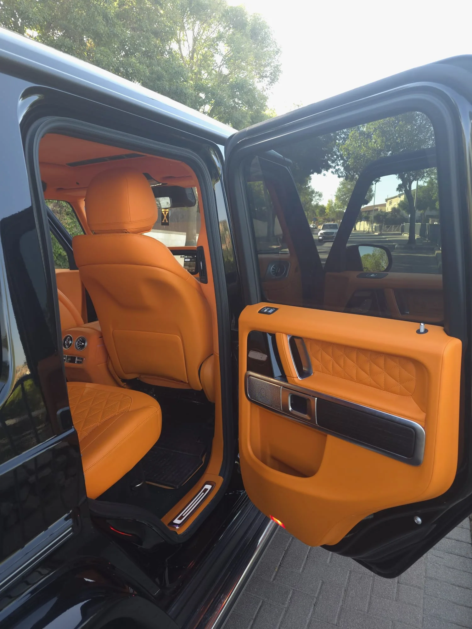
Ramat Gan translates roughly as “Garden Heights,” and the name still fits this dense city. It was founded in 1921 as a small farming settlement on low limestone hills east of Tel Aviv. Today the towers of the Diamond Exchange District rise on its western edge, while the southeast opens into lawns, eucalyptus groves and a lake. With a wedding car rental in Ramat Gan, both settings fit into one afternoon.
In between lie older streets of houses and gardens, a one-way shopping street and apartment towers along Jabotinsky Road. Black outside and orange quilted leather inside, the G63 looks crisp against a curtain wall and softer beside water and trees. Hand the keys to a chauffeur, or drive it yourselves. Below: where to pose, how to leave each type of building on the morning itself, and which roads to know.
01 · Ramat Gan
Why couples in Ramat Gan choose the G-Class
A garden city on hills
Richard Kauffmann's garden-city plan put three gardens on the hilltops, Gan Avraham, Gan Shaul and Gan Yehuda, and they gave the city its name. None of the hills reaches 100 meters, yet they leave streets that climb and dip, pine trees and small lookouts that frame a car well.
Towers that grew from diamonds
The Diamond Exchange District began with the Shimshon Tower, completed in 1968, the first office building in Israel with a curtain wall. Towers kept rising around it, the Moshe Aviv Tower among them, and since 2017 several streets have gained wide pedestrian plazas. At dusk the glass bounces city light onto the G-Class's black paint.
Where the neighborhood meets the park
Ramat Hen, a horseshoe-shaped neighborhood of mostly private houses, borders the National Park to the east. Mayor Avraham Krinitzi pushed for the park; planting began in 1951 and it opened to the public in 1953. From a Ramat Hen doorstep, the eucalyptus and the lake are only a few streets away.
02 · Pickup
Pickup on the day in Ramat Gan
The morning may start on a high floor or behind a garden gate. Residential skyscrapers line Jabotinsky Road and the blocks around the Diamond District, so ask the building management whether a car can wait briefly by the main entrance or only in a side bay. In Ramat Hen, where most homes are private houses, the car can usually pull up near your gate, wherever the curb allows it.
Typical pickups
- A high floor in a Jabotinsky Road tower, then down to the lobby
- A garden house in Ramat Hen, on the edge of the National Park
- A Diamond District hotel suite, with the first photos among the towers
- Your parents' home near Bialik Street, whose shopping stretch runs one way, southbound
03 · Photos
Photo stops with the car in Ramat Gan
- 01
The Diamond District streets
On Ohaliav, Tuval and Bezalel Streets, pedestrian plazas sit beneath office and residential towers, including the Moshe Aviv Tower. In the blue hour after sunset the windows light up and their reflections slide across the black hood. A covered footbridge links the district to the Savidor Center railway station.
Before using a building's entrance plaza, ask its management.
- 02
The lake in the National Park
Known locally as Park Leumi, the park's lake was dug in 1959 and enlarged into the early 1970s. Winter rain from the Kofer stream fills it, an artificial waterfall feeds it in summer, and since 2022 a four-kilometer (2.5-mile) loop has circled it, with swans around the island in the middle.
The paths are for walkers: leave the G63 in one of the lots around the park and walk in.
- 03
City Hall and its flower clock
Ramat Gan City Hall, at 35 Bialik Street near Rambam Square, went up in 1941–1942 in the International Style. A sculpture garden and a large flower clock surround it, and the lot slopes toward the valley between the hills, so you can stand above while the car waits on the street below.
City offices work inside, so the session stays outdoors, and the car pulls in only where signs permit.
- 04
The Spiral House and Dubiner House
On Tzel HaGiva Street near Har HaBanim, two apartment buildings by architect Zvi Hecker face each other. Dubiner House, known for its hexagons, dates from 1961–1963. The Spiral House, finished in 1990, coils around a courtyard, its concrete faced with pink stone, glass fragments and corrugated metal.
People live in both, so keep to the sidewalk and out of the courtyards.
04 · Event areas
Where weddings happen around Ramat Gan
- In Ramat Hen, a long-established complex of a hotel, a sports club and a convention center covers about 80 dunams (some 20 acres), and its large convention hall also hosts family celebrations.
- Two of Ramat Gan's four hotels stand in the Diamond District, one of them doubling as a conference center.
05 · The route
Planning the drive in Ramat Gan
Two highways frame the city. To the west, the Diamond District reaches the Ayalon (Highway 20) and Tel Aviv over the Moda'i and HaHalacha bridges and the Arlozorov interchange. To the east lies Highway 4, where Route 471 begins at the Bar-Ilan interchange, south of the university. In the south, Aluf Sadeh Road connects Derech HaShalom in Tel Aviv with Highway 4.
Jabotinsky Road (Route 481) heads east from Elite Junction toward Bnei Brak and Petah Tikva, with the Red Line underground beneath it, while Abba Hillel Silver Road climbs from the towers toward Ayalon Mall. The Purple Line is being built on Aluf Sadeh Road, so check its traffic arrangements before you lock in times.
- Ayalon Highway (Highway 20) and the Arlozorov interchange
- Jabotinsky Road (Route 481), east from Elite Junction
- Abba Hillel Silver Road
- Aluf Sadeh Road (Purple Line construction)
- Highway 4 and the Bar-Ilan interchange, start of Route 471
06 · Chauffeur or self-drive
A wedding car with a chauffeur in Ramat Gan
Ramat Gan is full of small logistics: the main shopping street runs one way, towers park cars underground, and the National Park is reached only from lots on its edges. Your driver drops you at the path to the lake, parks legally and returns when the photographer finishes, then handles the cross-town leg. Booking the G-Wagon chauffeured keeps it in your pictures and off your to-do list.
07 · Nearby
Near Ramat Gan
08 · Booking
How booking works
- 01
Send your details
Your date, the city and rough hours, on WhatsApp, by phone or with the form.
- 02
We check the date
We check availability and get back to you with a clear quote.
- 03
Confirm and reserve
Once you confirm the booking, the date is held for you.
- 04
Plan the day together
Addresses, times, the route and photo stops, a few days before the wedding.
09 · Questions
Questions about a wedding in Ramat Gan
What's the plan for photos by the National Park lake?
Leave the car in one of the lots on the park's edge, for example by Winter Stadium, by the Safari or on Peretz Bernstein Street, and walk in from there. The loop around the lake runs about four kilometers, so choose one or two spots with your photographer. For shade, start on the Naomi Shemer Trail in the eucalyptus grove near the south entrance.
Is there roadwork we should know about?
Yes. The Purple Line is under construction along Aluf Sadeh Road, which links southern Ramat Gan with Highway 4. In January 2025 the lanes toward Tel Aviv there were cut from three to two, with warnings of morning jams reaching Kiryat Ono, Highway 4 and Route 471. If your home or hall is in southern Ramat Gan, check conditions in the days before.
Sources for this page (17)
- Wikipedia: Ramat Gan (founded 1921, “Garden Heights,” limestone hills)
- Wikipedia (Hebrew): Ramat Gan (Kauffmann garden-city plan, three hilltop gardens, hills under 100 m, Ramat Hen, hotels)
- Wikipedia: Diamond Exchange District (Shimshon Tower, Moshe Aviv Tower, footbridge to the railway station)
- Wikipedia (Hebrew): Diamond Exchange District (first curtain-wall office building, street renewal since 2017)
- Wikipedia: Ramat Gan National Park (Krinitzi, planting 1951, opened 1953, lake 1959)
- Wikipedia (Hebrew): National Park, Ramat Gan (lake, waterfall, 4 km path since 2022, Naomi Shemer Trail)
- ice, 3 April 2023: parking lots around the National Park (Winter, San Martin, Safari, Peretz Bernstein)
- Wikipedia (Hebrew): Ramat Gan City Hall (35 Bialik Street, 1941–1942, sculpture garden and flower clock)
- Wikipedia (Hebrew): Bialik Street, Ramat Gan (shopping stretch one-way southbound)
- Wikipedia: Spiral House (Zvi Hecker, opened 1990, pink stone, glass and corrugated tin facade)
- Wikipedia (Hebrew): Dubiner House (1961–1963)
- Wikipedia (Hebrew): Maccabiah Village (Ramat Hen, about 80 dunams, convention hall used for celebrations)
- Wikipedia (Hebrew): Red Line (underground stations along Jabotinsky Road in Ramat Gan)
- Wikipedia (Hebrew): Route 481 (Jabotinsky Road)
- Wikipedia (Hebrew): Route 471 (begins at the Bar-Ilan interchange)
- Wikipedia (Hebrew): Ayalon Highway (Highway 20)
- Walla! Cars, 15 January 2025: lanes cut on Aluf Sadeh Road for Purple Line works

Availability