Wedding car service · Petah Tikva
Wedding Car Rental in Petah Tikva
If you're new to Israel, one word unlocks Petah Tikva: moshava. Before the kibbutz and its shared property, Jewish settlers founded moshavot, farming villages on privately owned plots. Founded in 1878, Petah Tikva is still called Em HaMoshavot, “Mother of the Moshavot.” A wedding car rental in Petah Tikva now serves a big city grown from that village, from Yarkon fields in the north to new districts in the south.
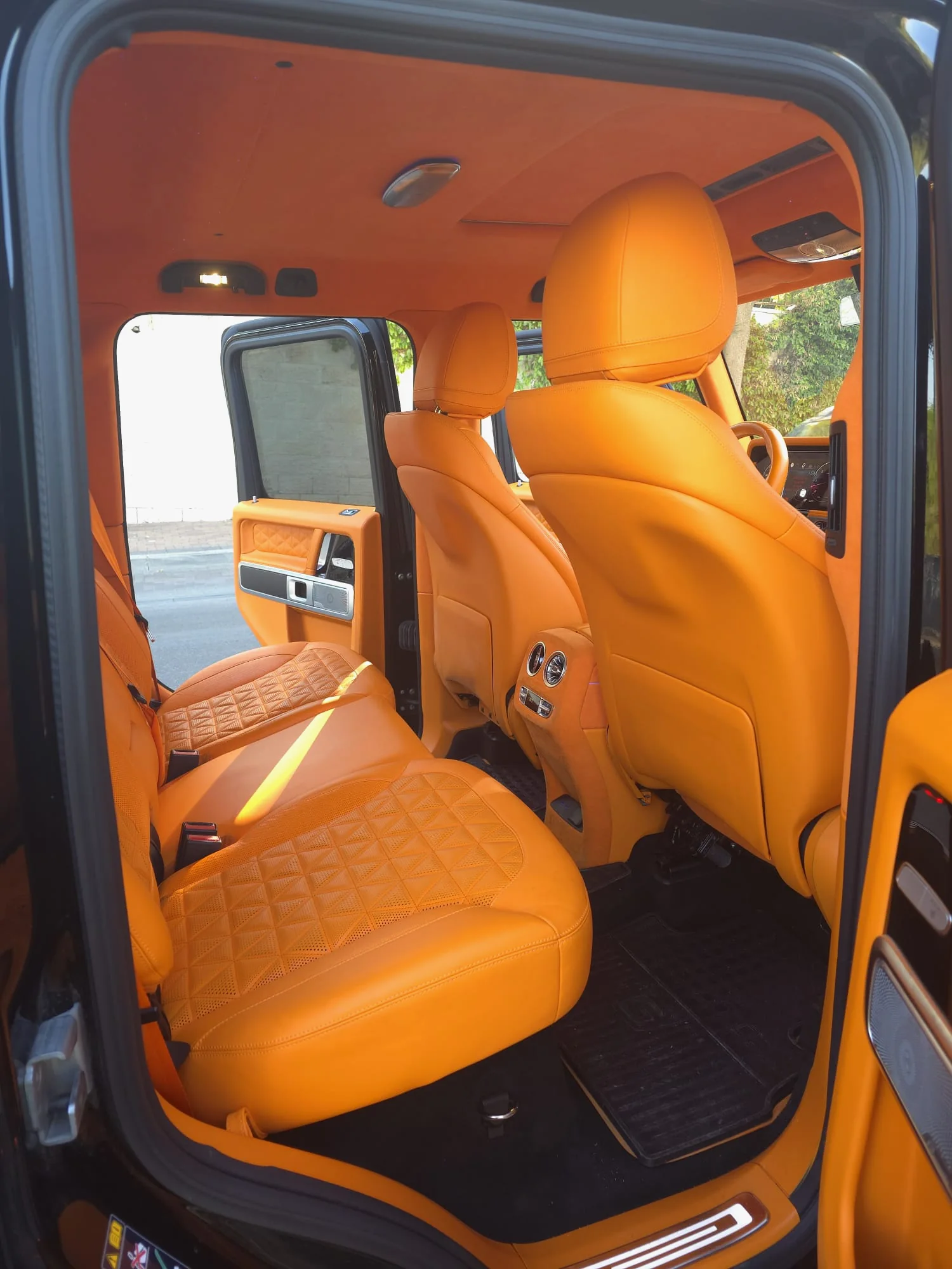
The old core survives around Founders' Square and Rothschild Street. Business parks spread west, and the Segula industrial zone in the northeast mixes event halls with factories. Each starting point changes the shape of the day. Book the black G63, trimmed in orange leather, chauffeured or self-drive, all arranged in English. Read on for photo spots, national park rules and switching highways without losing the afternoon light.
01 · Petah Tikva
Why couples in Petah Tikva choose the G-Class
Threshing floor, well, first furrow
On a low hill in the center, the settlers of 1878 set up a threshing floor, built their homes around it and dug a well; that December they plowed the first furrow. Today the hill is Founders' Square, with a fountain where the well stood and reliefs of the founders on horseback.
Fields inside city limits
Along the Yarkon River in the north, fields, orchards and open land still cover about a third of Petah Tikva. The Israel National Trail follows the stream there, and seasonal pools fill in November and December and dry out by May. Water, tall grass and big sky, without leaving town.
A big city, long crossings
Petah Tikva is Israel's fourth-largest city by population, with three large employment zones, an old center and new neighborhoods built over citrus groves, such as Kfar Ganim C. Home, photo spot and hall can sit on opposite sides of town, so the drive belongs in the plan.
02 · Pickup
Pickup on the day in Petah Tikva
Neighborhoods here differ the moment you step outside. In the new Em HaMoshavot quarter most buildings rise 9 to 23 floors, so agree on a stopping point near the lobby, away from the garage ramp. In Beilinson, a neighborhood of private houses only, and in Neve Oz, the car can often wait almost at the gate. If your building has several entrances, tell us which one you'll use.
Typical pickups
- An Em HaMoshavot tower, out through the main lobby
- A private house in Beilinson or Neve Oz
- Parents on Jabotinsky Road, with Red Line trains down the middle
- Tel Afek before closing time, then the drive to a hall in Segula
03 · Photos
Photo stops with the car in Petah Tikva
- 01
Founders' Square (Kikar HaMeyasdim)
The square has two levels, a raised lawn and a paved section at street level, with a fountain marking the old well. Beside five marble plaques to the founders stand a roofed pavilion that recreates the old bandstand and a metal sculpture of the first plowing.
Pedestrians only; the G-Class waits legally on Shtampfer, Baron Hirsch or Pinsker Street.
- 02
Yad Labanim Park and the Givat HaShlosha dining hall
Independence Garden on Arlozorov Street, known to all as Yad Labanim Park, was laid out in the early 1950s by landscape architect Lipa Yahalom, beside the Petah Tikva Museum of Art. Across the road stands the restored dining hall of the old Givat HaShlosha kibbutz, a collective farm, designed by Arieh Sharon in 1936.
Yad Labanim House in the park is a memorial to fallen soldiers; keep the session respectful and at a distance.
- 03
The fortress and lake at Tel Afek
In Yarkon National Park, reached from Route 483 between Petah Tikva and Rosh HaAyin, an Ottoman fortress from the 1570s crowns the ancient mound. Its name, Binar Bashi, means “head of the springs.” An artificial lake lies below, and a loop path climbs from the water to the walls.
Personal photos of the couple in visitor areas need no permit from the Israel Nature and Parks Authority; a shoot for publication or marketing must be requested from the Authority's spokesperson 14 or more business days in advance.
- 04
Raab House and the old lemon-scented gum
At 50 Rothschild Street stands the house Yehuda Raab, who plowed the first furrow, built in 1901; his daughter, the poet Esther Raab, grew up there. At 8 Shapira Street, a lemon-scented eucalyptus planted in 1910 is now a city heritage site.
The house is on the city's conservation list: pictures from the sidewalk, not the yard.
04 · Event areas
Where weddings happen around Petah Tikva
- The Segula industrial zone in the northeast has many event halls and event gardens next to shopping centers and factories, west of Route 40 and south of Highway 5.
- Halls in Tel Aviv or Ramat Gan are reached by heading west on Jabotinsky Road or Em HaMoshavot Road.
05 · The route
Planning the drive in Petah Tikva
Each highway around Petah Tikva points somewhere different. Highway 5 in the north heads west to Tel Aviv, with the Tikva interchange on the west side and the Yarkon interchange in the east. Highway 4, which locals call Geha, touches the city at the Geha interchange, and Route 471, the Maccabit road, runs along the south.
Highway 5 keeps a steady rhythm: heavy toward Tel Aviv in the morning, heavy back toward Petah Tikva and the towns east of it from the afternoon on. An evening wedding can land right in that stream. Jabotinsky Road doubles as the Red Line corridor and leads through Bnei Brak to Ramat Gan.
- Highway 5: Tikva and Yarkon interchanges
- Highway 4 (Geha): Geha interchange
- Route 40: Segula, Ganim and Sirkin junctions
- Route 471 (Maccabit): Nachshonim, Petah Tikva South and Gat Rimon interchanges
- Jabotinsky Road (Route 481) and Em HaMoshavot Road
06 · Chauffeur or self-drive
A wedding car with a chauffeur in Petah Tikva
Your day may run from a neighborhood in the south to a square in the center, a national park on the eastern edge and a hall in the northeast. A driver who knows the plan picks the roads, finds legal stops near Red Line stations and orders everything so you reach Tel Afek before the gate shuts. Your part: the dress, the photographer, a quiet minute in the back seat.
07 · Nearby
Near Petah Tikva
08 · Booking
How booking works
- 01
Send your details
Your date, the city and rough hours, on WhatsApp, by phone or with the form.
- 02
We check the date
We check availability and get back to you with a clear quote.
- 03
Confirm and reserve
Once you confirm the booking, the date is held for you.
- 04
Plan the day together
Addresses, times, the route and photo stops, a few days before the wedding.
09 · Questions
Questions about a wedding in Petah Tikva
Can the G-Wagon come along for photos at Tel Afek?
Yes, with one limit: the car stays off the paths. Tel Afek is part of Yarkon National Park, where the Israel Nature and Parks Authority has visitors register ahead and pay an entry fee. Shots with the G63 happen in the parking area or on the access road; the fortress and lake are done on foot. Shooting for publication too? Ask the Authority about a permit.
Can we shoot at Tel Afek at sunset?
Usually not. Going by the Parks Authority's posted hours, the park closes in summer at 5 p.m. Sunday through Thursday and on Saturday, and at 4 p.m. on Friday, as the country winds down for Shabbat; winter hours are an hour earlier, and last entry is an hour before closing. Plan Tel Afek for early afternoon and save sunset for Yad Labanim Park or the Big Park on Jabotinsky Road.
The hall is in the Segula zone. Which approach works?
Segula occupies the city's northeast corner, between Route 40 and Highway 5 with its Yarkon interchange. From Tel Aviv or Ramat HaSharon, Highway 5 is the obvious approach; from southern Petah Tikva, go north on Route 40 through the Sirkin and Ganim junctions. In the evening, allow extra time on eastbound Highway 5.
Sources for this page (14)
- Wikipedia: Petah Tikva (founded 1878, “Mother of the Moshavot,” fourth-largest city, Segula event halls)
- Wikipedia (Hebrew): Petah Tikva (a third of the area green, employment zones, neighborhoods, Big Park, Raab House, lemon-scented eucalyptus)
- Wikipedia: Moshava (privately owned land, unlike the kibbutz and moshav)
- Wikipedia (Hebrew): Founders' Square, Petah Tikva (two levels, fountain at the well, plaques, bandstand, first-plowing sculpture)
- Wikipedia: Antipatris (Tel Afek, Ottoman fortress Binar Bashi, Yarkon-Tel Afek National Park)
- Wikipedia (Hebrew): Yarkon National Park (lake, fortress 1572–1574, access from Route 483)
- Israel Nature and Parks Authority: Yarkon National Park, Tel Afek (opening hours, advance registration)
- Israel in Photos: Yarkon Springs visitor guide (summer and winter hours)
- Israel Nature and Parks Authority: requests for photography approval
- Wikipedia (Hebrew): Red Line (opened 18 August 2023, surface stations in Petah Tikva)
- Wikipedia (Hebrew): Highway 5 (morning and evening traffic pattern, Tikva interchange)
- Wikipedia (Hebrew): Route 471, Maccabit road
- Wikipedia (Hebrew): Route 40 (Yarkon interchange, junctions)
- Wikipedia (Hebrew): Route 481, Jabotinsky Road to Segula Junction

Availability